
 |
| Creative Commons |
I started with research online and thought I found a great resource, a site called Forgotten Ohio. I was particularly interested in the page on Cheshire, Ohio, a town down along the Ohio River. It sounded perfect for my purposes. From the site's description:
It's a pretty strange occurrence for an entire town to be wiped off the map in the span of two or three years. That's what makes the case of this Gallia County hamlet so noteworthy. Cheshire, a town located just upriver from Point Pleasant, WV (where the infamous Mothman was sighted in the late 1960s), is in the process of becoming Ohio's latest ghost town.
 The site explained that the local power plant had reached a settlement with the residents of the town, which sued over the pollution from the plant. AEP offered to buy out the residents, and the town began to empty of people. The site had pictures of boarded up homes and described the streets as virtually deserted in 2003. I thought it would probably be in even rougher condition today. It was possible there wouldn't be anything there, I thought. The article had mentioned AEP might use it for storage of coal or equipment, so they might have torn down the buildings. There weren't any Urban Explorer photos I could find, so it might be gone. But, it was worth a shot, I figured.
 So, my True Love and I made the long drive, stopping to photograph things we saw along the way. I took along with me a representation of Sam and Tigger from the book.
We got to Cheshire and I was surprised to see... a bustling little town. We drove around the town, confused. Where was the abandoned houses the blogger described? The blight? The empty streets. The abandoned pizza parlor he'd described... the empty post office... The pizza place was open and the post office had people going in and out of the door. We didn't see one abandoned house.

 An example of that horrifyingly ugly Brutalist architecture of the 1970s, the building is beginning to quickly decay without maintenance. A peek through the glass doors revealed a large puddle of water on the floor around the cardboard boxes stacked inside.
It struck me as odd that the school has been closed for a number of years, but the banner "Quality Education For Quality Kids" is still hanging on the front of the building.

The town is dwarfed by the massive nuclear power towers and smokestacks of the coal-fired power plant.
I can only figure AEP must have re-sold the residential and commercial property of those who sold out and moved, or not many people took advantage of the deal.
After visiting the ghost-town-that-wasn't, we decided we needed to re-evaluate the reliability of the sites we'd been using as a guide and find more modern information. Okay, lesson learned: don't expect that a town teetering on the brink of oblivion won't recover.
We chose Thurmond, West Virginia as our next destination. Along the way, we did spot some abandoned houses here and there. We stopped so I could photograph this one.


 In the main room was this pair of children's shoes on the floor, which looked like the child had walked right out of them. On the floor ahead is a new-ish stuffed animal.
Seriously creeped out, I decided it was time to move on.


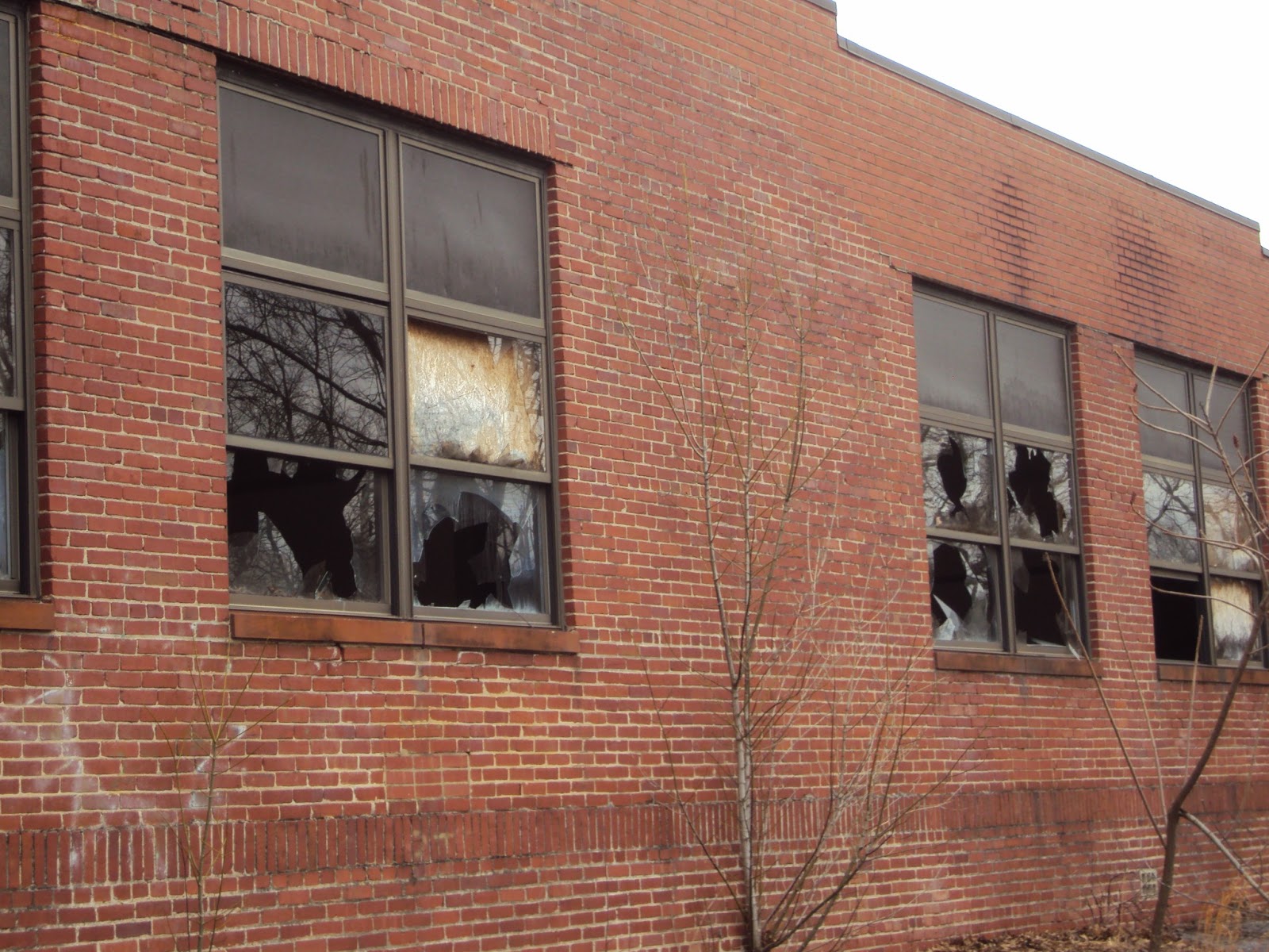 The building was severely damaged. Almost every window is broken and the doors at the back were hanging ajar.

 Inside, the floor was covered with crumbled plaster and other debris. All of the furniture was gone, which disappointed me because I wanted to photograph a decaying desk or two.
 The only things inside were this painting of a blue lion with golden curls laying on the floor and a lone boot, abandoned near the door. I admit, I pondered that one for a while. How does one lose a single boot in the ruins of a school building?
 We continued on our way on route 19, and I saw something in a field that caught my attention near Kegley. The area is also known as Clover Bottoms. There was the remains of a large camp grounds which once had a small amusement park near a pond. A rusted Ferris wheel stood silently in a large field, with a swing ride nearby.
There was no way to get closer from this direction because it was fenced off, so we drove down the road and around the curve. From that angle, there was no fence, but a wetland kept me from getting very far into the field.

I was trying to get just a little bit closer when I saw this sticking up out of the boggy soil ...

It was a memorial stone, all alone, with nothing further to mark the spot, lost among the weeds and brush. It reads, In memory of BARTLEY AND TABITHA CLAY massacred by Shawnee Indians, Aug. 1783. Children of Mitchell and Phoebe Clay, first settlers of Mercer County. Erected Aug. 14, 1937 on exact site of the graves.
Once I got home, I was able to do some research. While the story of the Clay children is remembered and memorialized elsewhere, including a brass plaque near the entrance to the park and a statue at the Princeton court house, this memorial stone is all but completely forgotten. On Find A Grave, the other memorial stones are pictured, but not this one. (I added it.)
The site was once a Fort Ancient Native American village and burial ground, abandoned a few hundred years before the Clay family came along. Archaeologists found thirteen burials, mostly of infants and children, but later examinations of the site suggested there are many, many more... as in thousands.
The Lake Shawnee amusement park opened up in 1926 and operated until the mid 1960s. It used to have 30 rides, including a roller coaster. Supposedly, the site is haunted by a little girl who was killed on the swing ride in the 1950s. Here is the paranormal investigation site; the owner now operates the park as a ghost hunt. Sadly, they don't seem to have noticed the memorial stone while they were there. Here's another, with close-up photos of the remaining rides.
~.~
My next post will feature my adventure at Thurmond. Stay tuned!
Wow, what a lot of good pictures you took. Creepy, sad, melancholy...
ReplyDeleteThat is so cool! The marker, that is. I'm a freak and adore rambling through old graveyards so I can read the headstones. Finding a marker like that would have sent me into paroxysms of joy!
ReplyDeleteIt kind of made me sad that it had been so utterly forgotten. I couldn't find an image of it anywhere online. I added it to "Find a Grave," so at least someone searching for the kids on that site will be able to see it.
DeleteI have been to the school in WV before but I forgot how to get there. Do you happen to have an address or a name of the school.. Just curious so I can return to take more pictures. Thanks! :)
DeleteUnfortunately, no. I stumbled upon it randomly, and all I know is that it was on Route 19. Sorry I can't be more help.
DeleteThank you for the amazing picture of the memorial, at the site. It's people like you, that know, somewhere, someone will be looking for their family. And here I am :) I found out I am related to these little ones ( through marriage) pretty far back, just today. One day I will make the travels like you have to find the rest. Have you by chance been to Black Wolf West Virginia? Its in Mc Dowell County.
DeleteYou're very welcome, Sandra Ann! I'm glad I can help relatives learn of this memorial. It shouldn't be forgotten. I haven't been to Black Wolf, but it sounds like an interesting place.
DeleteLissa, May I have your permission to use the photos of the ferriswheel and Clay children stone for our Clay Family Society newsletter? We plan to visit the lake and the memorial on the hill above during our biennial Gathering this June.
ReplyDeleteSure! Hopefully, you'll be able to find the stone easily. I'd love to see a copy of the newsletter, if you wouldn't mind sending it to me.
Delete